I. — Introduction
The Strait of Dover and the Boulonnais correspond to a complex geologic structure, for a long time considered as an anticline. This complex structure is the result of a tectonic inversion affecting the Mesozoic Weald-Boulonnais basin (Ziegler, 1992; Coward, 1994; Mansy et al., 2001). The "anticline" axis, nearby the Variscan Front, is partially connected to the Variscan overthrust structures. A first inversion occurred at the Jurassic-Cretaceous limit (Mansy et al., 2001). The second phase of inversion is Cenozoic and would be situated or in the limit Eocene-Oligocene (Ziegler, 1992; Coward, 1994) or would be synchronous with inversions recognized for Wessex and some basins of the North Sea, at the end of Oligocene or at the beginning of the Miocene (Ziegler, 1992). Nevertheless, the simultaneity of the inversion of the zone Weald-Boulonnais with that of the Isle of Wight appears, likely, Paleogene in age (Gale et al., 1999; Vandycke and Bergerat, 2001; Mansy et al., 2001). The evidences for younger movements had not allowed the reconstruction of the story since the beginning of Neogene. Some recent observations bring to light tectonic reactivation during the Neogene and in the Pleistocene (Van Vliet-Lanoë et al., 1998; - 2000).
The opening of Strait of Dover in Cenozoic and the tectonics of the whole Weald – Boulonnais basin are poorly known and raise controversies. In the majority of the publications, the opening of Strait of Dover and the Boulonnais' excavation are always considered as Pleistocene (Sommé, 1977; Alduc, 1979; Ziegler, 1992; Colbeaux et al., 1993; Gibbard, 1995; Jones, 1999; Sommé et al., 1999; Lefèvre & Sommé, 2001) although some authors remain dubious (Larsonneur, 1971 ; Curry, 1992 ; Bridgland & D'Olier, 1995 ; Meijer & Preece, 1995; Van Vliet-Lanoë et al., 1998 , 2002, 2004; King, 2006).
This strait is according to Pomerol (1973) functional during early Paleocene and is temporarily closed during lower Ypresian and more effectively from the Middle Lutetian. From 1968 and in 1978, Margerel suggested an opening from the Pliocene because of the homogeneity of the foraminifer's faunae in the Channel and the Southern North Sea. For Curry (1992), the strait seems open during the lowest Oligocene. Also for him, the large proportion of warm species in the Pliocene of the Red Crags is an argument in favour of a re-opening of the strait from the Pliocene, also confirmed by Meijer & Preece (1995). Dingwall (1975) also published the occurrence of Pliocene deposits in the northern prolongation of the Lobourg Deep (fig.1) which incised the Strait. We proposed a regressive capture of the western Channel by the North Sea in relation to a temporary Messinian uplift of the Variscan front (Van Vliet-Lanoë et al. 1998) by the Pliocene Lobourg River. The strait was closed again since the Early Quaternary (Meijer & Preece 1995). According to malacofaunal evidences, the Strait remained closed until MIS 5e (Meijer & Preece 1995).
The age for an opening in the Pleistocene is based in France and in Belgium on the stratigraphic and climatic interpretation of the Formation du Fart / Slack which crops out at Wissant and at La Pointe-aux-Oies (de Heinzelin, 1964; Roep et al., 1975) and on the succession of "Quaternary" paleosurfaces inside the depression of the Boulonnais (de Heinzelin, 1964). De facto, the uplift of the Boulonnais and its excavation were thus attributed to the Pleistocene time. A first synthesis was published in 2004 (Van Vliet-Lanoë et al.) shifting this interpretation back to the Neogene. Since, complementary works have allowed to precise some of the remaining questions on both the North Sea and the Eastern Channel sides. A systematic reinterpretation of the old sections, new descriptions made in 1968-69 and since 1996, sections observed during the works of the coastal highway and those of the Channel Tunnel (Antoine, 1991) allowed clarifying some uncertainties (Van Vliet-Lanoë et al., 1998, 2002). The important present-day retreat of the coastline between 1996 and 1999 also allowed new observations.
Concerning the Weald, its morphology is similar to that of the Boulonnais, but with a stronger relief. Woolridge & Linton (1939) considered that the excavation of the Weald was post-Pliocene because of the age initially attributed to the Lehnam beds. The inner surface develops through the Weald at +100 - +120 m although somewhat deformed by internal flexures and foldings. It corresponds a marine abrasion surface reworking partly the top of the Jurassic “Upper Green Sands” especially from the Ashford to Lehnam districts. Concerning Plio-Pleistocene river evolution in the Weald, the Wey, Blackwater, Medway and Stour Rivers are believed to flow northwards in a parallel course across East Anglia and the western shelf of the south-western North Sea, before shifting eastwards (Bridgland, 1988). Green (1985) and Jones (1999) date this incision back to the Eocene, accentuated by an emersion since the Chattian (late Oligocene).
Our paper is a reappraisal of the stratigraphical positioning from various outcrops and paleosols preserved inside the Boulonnais and replaces the recorded events within the morpho-tectonic and climatic context of the Cenozoic. The middle Miocene is well recorded in Belgium and in the North Sea, in Brittany and on the low of Cotentin but was not recorded in the Boulonnais and adjacent regions. We also recognized the existence of an upper Miocene shore along the present-day coast. This reappraisal of the stratigraphic record in parallel with the steps of the tectonic inversion allows a better insight of the mechanisms responsible for the formation and opening of the Strait of Dover, as also of the eustatism and the tectonic history of Western Europe. Finally, we shall see that this major geological structure does no behave differently from the other inverted basins of Western Europe.
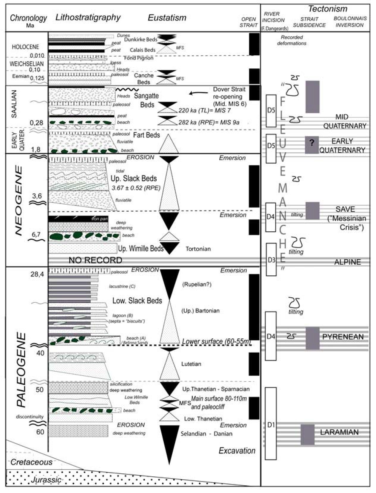
The altitudes are given in metres NGF on the French side and metres OD on the British one, the Quaternary ages in MIS or Marine Isotopic Stages.
II. — The structural context
The Strait of Dover is located at the contact between two large western European domains situated on the edge of the northern Variscan front (fig.1). In the South, the equivalent of Brabant Parautochton crops out essentially in Marquise's region. Several structural units are separated by southward pending overthrusts limited by listric faults (Mansy et al., 2001). Whole the overlapping units are truncated by a vertical faulted zone line, Permo-Trias in age, the fault of Pernes (Lewandowski et al., 1999). Extensive phases deform this region during the Permo-Trias and the upper Jurassic to the lower Cretaceous. The morphology of the Boulonnais is then controlled by the inversion of this zone corresponding to the oriental extremity of the Weald's basin. It is not a real anticline, but succession of “en échelon” flexures controlled by the presence of a thin Mesozoic sedimentary cover on the Palaeozoic basement. This “thin skin” tectonic is controlled by N100 faults dipping to the North (Mansy et al., 2001). The most important ones appear close to Landrethun and in the Artois. The St Omer's basin, develops at the NE of one of these fault zones, which behaves as a flexure. North of the strait, the Southern zone of the North Sea is characterized by a steep dip to the NE (Henriet et al., 1989), with several NW-SE faults, prolongation of the South Heweth fault zone. From 1972, Shephard-Thorn et al. noticed the importance of the reactivation of the Paleozoic deep structures on the morphology of this region of Europe. Under enhanced compression, the whole domain, south of the Variscan deformation front, lifts up and tilts to the SW, while the Anglo-Brabant zone lifts up and tilt to the NE.
Figure 1
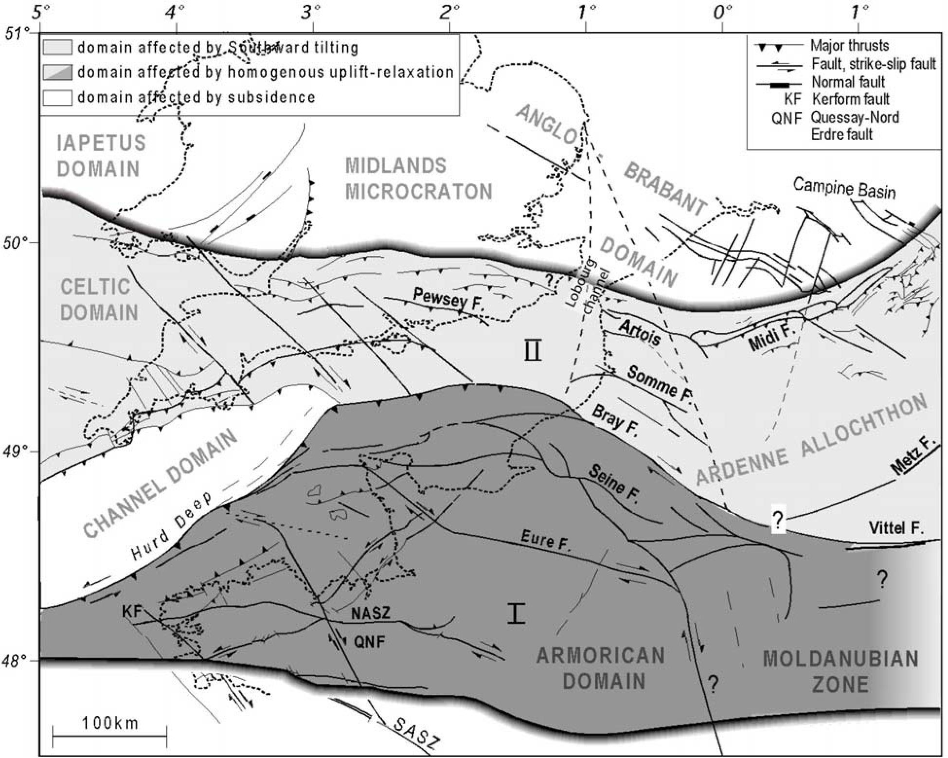
Global map of the deep geological basement of the English Channel and Southern North Sea (from Mansy et al., 2001).
Carte globale de la structure géologique profonde de la Manche et de la Mer du Nord méridionnale ( Mansy et al., 2001).
An important point has been the “official” absence of the Neogene and of a part of the Paleocene in the Boulonnais. The Pliocene would be essentially preserved north of it (Pomerol, 1973) and the traditional limit for the Pliocene transgression is limited to the North of the strait, along the subsiding N compartment of the Landrethun's flexure and these “en échelon” of Sangatte. Opposite, in the eastern Channel, its northern extent would not exceed Fécamp (Pomerol, 1973). The observations made in the years 19701975 and after 1996 allowed to infirm this assertion. For that traditional interpretation, the zone of the strait sensu stricto was interpreted as an early Quaternary graben as suggested by Colbeaux et al., (1993). The last data show that the strait zone roughly corresponds to a series of flexures of orientation WNW / ESE (Hamblin et al., 1992; Mansy et al., 2003) controlled by the inversion of Weald, globally evolving in a synform morphology, the inversion being more important along the English side.
The works of the Channel Tunnel show on the French side a series of tilted blocks denoting a considerable transpression in Cenomanian chalks (Ziegler, 1992). The Fosses Dangeard, located within the strait, are strongly controlled by these structures (fig. 3). We need to give an age to these deformations.
The onset of the inversion
The sedimentary record from the Cenozoic is very discrete in the Boulonnais. The Bray is relief emerging by inversion by the late Cretaceous, and the Boulonnais seems to be activated at this time (Lamarche et al., 1998). At Sangatte, below the raised beach and the Plenus Marls (Upper Cenomanian), evidences exist, close to the main fault, of creep in the chalk, enhanced by ice segregation during the middle Pleistocene (Van Vliet-Lanoë et al., 2004). It thus seems that the inversion of this sector begins from the middle Cretaceous (upper Cenomanian; Bergerat & Vandycke, 1994). This tectonic activity is also registered in the North Sea (Badley et al., 1998) and in Kent (Bergerat & Vandycke, 1994). Also the limited preservation of the post-Cenomanian chalk in the western basin of Paris confirms a slight uplift of the Bray (Mortimore & Pomerol, 1997) at that time. These events are contemporary with the Subhercynian and Laramian phases, defined for the Western Europe in the eustatic chart of Shell (in Ziegler, 1990).
Figures 2 and 3
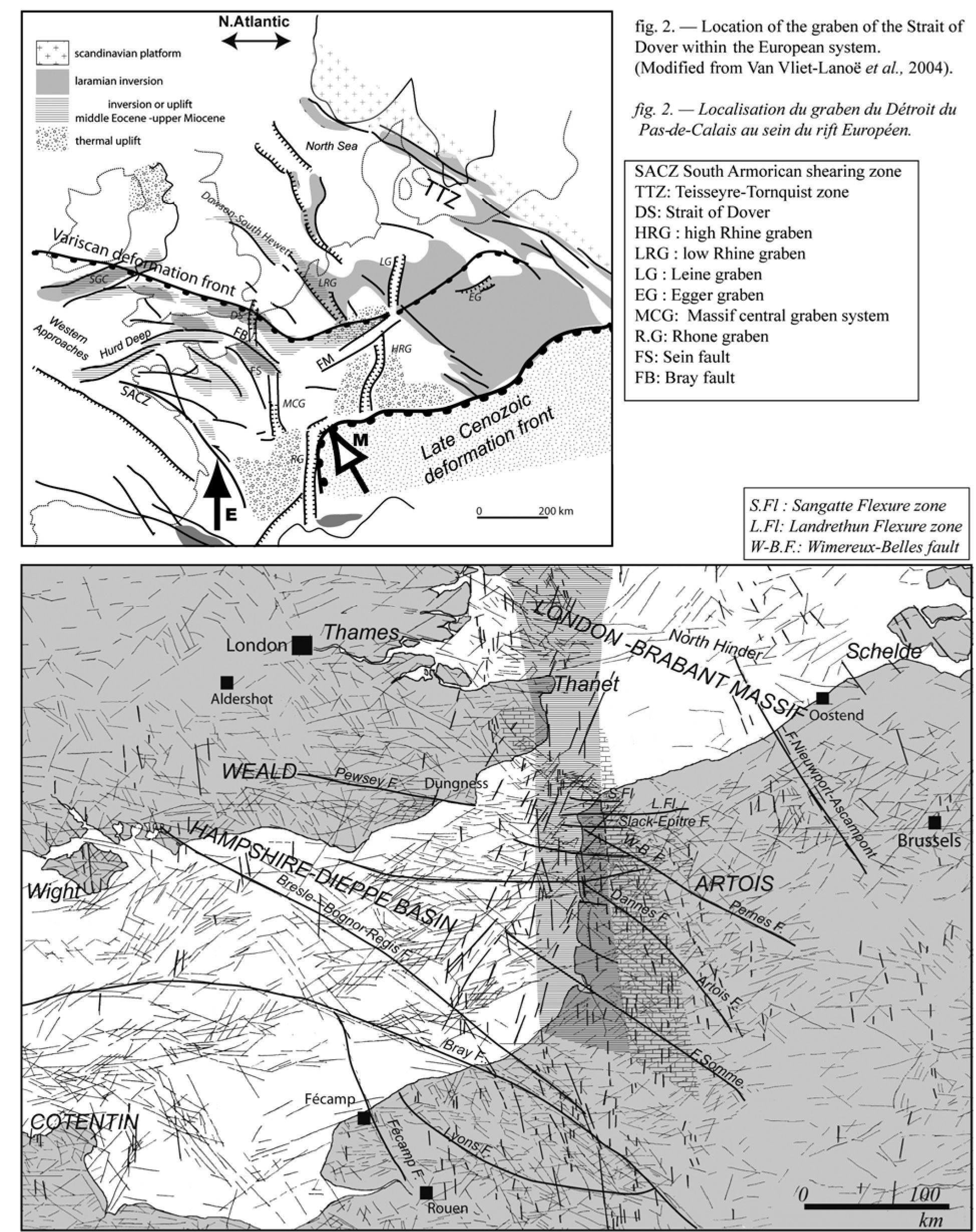
Figure 2 : Location of the graben of the Strait of Dover within the European system. (Modified from Van Vliet-Lanoë et al., 2004).
Localisation du graben du Détroit du Pas-de-Calais au sein du rift Européen.
Figure 3 : Positioning of the "graben" of the strait of Dover from the lineations extracted from DEM and topographical maps. For the Channel and the Strait, the used maps are those of Alduc, 1979 and Kellaway et al., 1985. For the Southern North Sea, the used map are those of Quaternary, BGS and various detail maps. The N-S lineations are emphasized to visualize there maximal concentration in the prolongation of the Massif Central rift system. The graben is marked by the dashed zine; the brick symbol locates the possible rift shoulders.
Positionnement du graben du Pas-de-Calais à partir des linéaments extraits de fonds topographiques et de modèle numériques de terrain. Les linéaments N-S ont été soulignés pour mettre en évidence la prolongation du système du Massif Central. La zone hachurée correspond à la zone du graben ; les briques à la position potentielle des épaules de rift.
However, the existence, upslope of the paleo-cliff of Sangatte, of a paleo-channel containing a mixture of blocks derived from Turonnian and Coniacian chalks (com. pers. F.Amédro) including flint pebbles of with a limonitic cortex and cobbles of goethithic or hematitic sandstones. It suggests an early emersion with some supergene weathering (Van Vliet-Lanoë et al., 2004). The Coniacian chalks crop on the top of the Boulonnais but are more developed on the Northern slope in the quarry of Coquelles (Robaszynski & Amédro, 2009). The preferential conservation of the upper Santonian on the Northern slope of the Boulonnais (Deconinck et al., 1989) and close to St Omer (Robaszynski & Amédro, 2006), while mostly absent at the Southern slope, would be an argument for a differential accommodation bound to some activity of the flexure zones of Landrethun and Sangatte. Nevertheless a recent analysis of the contents of the Lower Slack Beds at the Pointe-aux-Oies (fig. 4, see further) gives evidence of the late erosion of the Santonian, as also the presence on the Boulonnais uplands of flints with the same faunal content in residual clays (L.Quesnel, BRGM personal com.). The first emersion dates probably back to the early Paleocene (Selandian; King, 2006). A first incision of the river net is recorded in the Mons basin in Belgium (Vandenberghe et al., 2004).
In Europe, during the Cenozoic, the Teisseire-Tornquist zone (TTZ) accommodated mainly the Laramian inversion although the Variscan front and the Bray accommodated the main part of the Pyrenean and Alpine tectonic phases (Van Vliet-Lanoë et al., 2004). The impact of the opening of the North Atlantic and the bulging created by the Greenland-Iceland magmatic centre some 63 Myr ago also led to the building of the regional stress affecting three major Variscan structures: the TTZ zone, the Variscan front and the Bray's fault (Nielsen et al., 2007). Then, an important thermal subsidence started at the very beginning of Eocene in the northern part of the North Sea and in Western Approaches of the Channel, with the onset of rifting in the North Sea basin (Ziegler, 1990; Nadin et al., 1995).
III. — The Cenozoic Stratigraphy of the Strait's zone
1) The Paleogene
The Paleocene
The majority of the Paleocene deposits of the Northern France consist in dark grey clays with some paleosols and sands, preserved in wide paleo-talwegs on the north slope of the Boulonnais while a basin continues to form at the foot of the Landrethun's flexure (St Omer basin: Desoignies & Thibaut, 1968). The series includes at its base greened flint pebbles as at Helfaut quarry (St Omer). On the Boulonnais, they are preserved in karst pits developed on transtension zones (Lower Thantian greenish sands with tidal facies). To the South, they are preserved at St Josse, on the plateau above the Canche River, covering both the Thanetian and the Sparnacian (Dubois, 1921; Destombes & Lapierre, 1974).
In the low valley of the Canche River (fig.4) and in the Picardy maritime plain, the dark green glauconitic sands and compact grey-black clays were found by drilling towards -10 m at Villiers. They correspond to the “sables d'Ostricourt” and “argiles de Louvil" belonging to the Thanetian of St Omer's basin or to “sables de Bracheux” of the Oise River valley (Destombes & Lapierre, 1974). The St Josse's coring located on the plateau south of the Canche River records a succession of facies from the upper Paleocene and basal Eocene up to the early Ypresian (+55m; Van Eetvelde and Dupuis, 2005). Locally a continental facies of early Ypresian brownish clay, the St Aubien clays is preserved. Above the estuary of the Somme river (+ 40 m), the St Valéry's sands also correspond to the very early Ypresian (Sparnacian facies; Dupuis, 1982). Synsedimentary deformational structures in Sparnacian of Belgium (Sintubin et al., 2001) are related to rapid tectonic uplift of both the Brabant Massif and the Artois axis (Vandenberghe et al., 1998).
Inside the Boulonnais, an azoic tidal fine sand, silicified is cropping out in the sector of Tingry and Samer villages (fig. 4), but also exists around the Mont des Dalles (c.+125 m), on the southern side of Boulonnais and at Fromessent (+57 m). It corresponds to the Paleocene “sarcens” of the residual deposits of Thanets Beds at Maidstone in the Weald (Worssam, 1963) and of the Thames river basin, issued from the silicification of Thanetian sands (Ellisson and Zalasiewicz, 1996) as also to the "ladères” sandstones of Brittany. In the Weald, the silicification (sarsens) took place with the aridification in the late Eocene (Green, 1985). These formations give evidence of a partial internal erosion of the Boulonnais from late Paleocene onward. Later the zone of the strait is described as emerged (Pomerol, 1973) and this phase of uplift seems generalized as Cavelier & Chateauneuf (1971) evidenced a modest uplift of Bray prior to the Ypresian.
Due to the structural context, this period covering the late Paleocene and the onset of the Eocene corresponds 1° to the post-orogen relaxation of the Laramian (Danian) but 2° also to the thermal bulging of Western Europe in connection with the development of the Greenland-Iceland hot spot (Paleocene-Eocene dykes in the British Isles and granite of the Lundy Island; Ziegler, 1990). Given the meridian direction of stresses on Western Europe at that time (Bergerat & Vandycke, 1994), it seems as likely that the beginning of extension facilitated a subsidence at the level of the Strait of Dover, disconnecting the Boulonnais of the Weald basin. It also seems probable that the river system sketched during the emersion of the very early Paleocene develops, exploiting the marked E-W structural pattern of the Boulonnais and of the Weald (Mansy et al., 2002). This is also the case on the Brabant Massif where valley incision is effective from c.56 Ma (Vandenbrghe et al., 2004).
A reappraisal of the lower formation de Wimille (Stinkal quarry): a high eustatic level form the late Ypresian ("Cuisien" facies ) (fig.6)
In the Boulonnais, the discovery of fine greenish tidal sands (micaceous and glauconitic) between + 90 and + 120 m of altitude, in particular close to + 110 m in the quarry of Stinkal near Marquise (fig. 4) (middle and lower formation of Wimille; Van Vliet-Lanoë et al., 2004), but also east of St Martin-de-Boulogne (+ 90 m) . We have initially given an Eocene to upper Oligocene age for this formation. These sands are strongly fractured, deformed by co-seismic structures (load casts). They look analogues to the sands of the Bagshot Beds or Boscombe Sands of the basin of Wight or the “Cuisiens" facies of the Oise river valley, late Ypresian in age. Late Ypresian deposits are also present on the north slope of the Boulonnais, at the base of the Noires Mottes hills (+ 120 m; Mansy et al., 2001) and also on the north side of Weald. This late Ypresian is also present under the city of Calais to the North and to the south at the Mont Hulin (Montreuil/ Canche River) where the facies also reworks silex gravels (Dubois, 1921; Destombes & Lapierre, 1974).
Figure 4
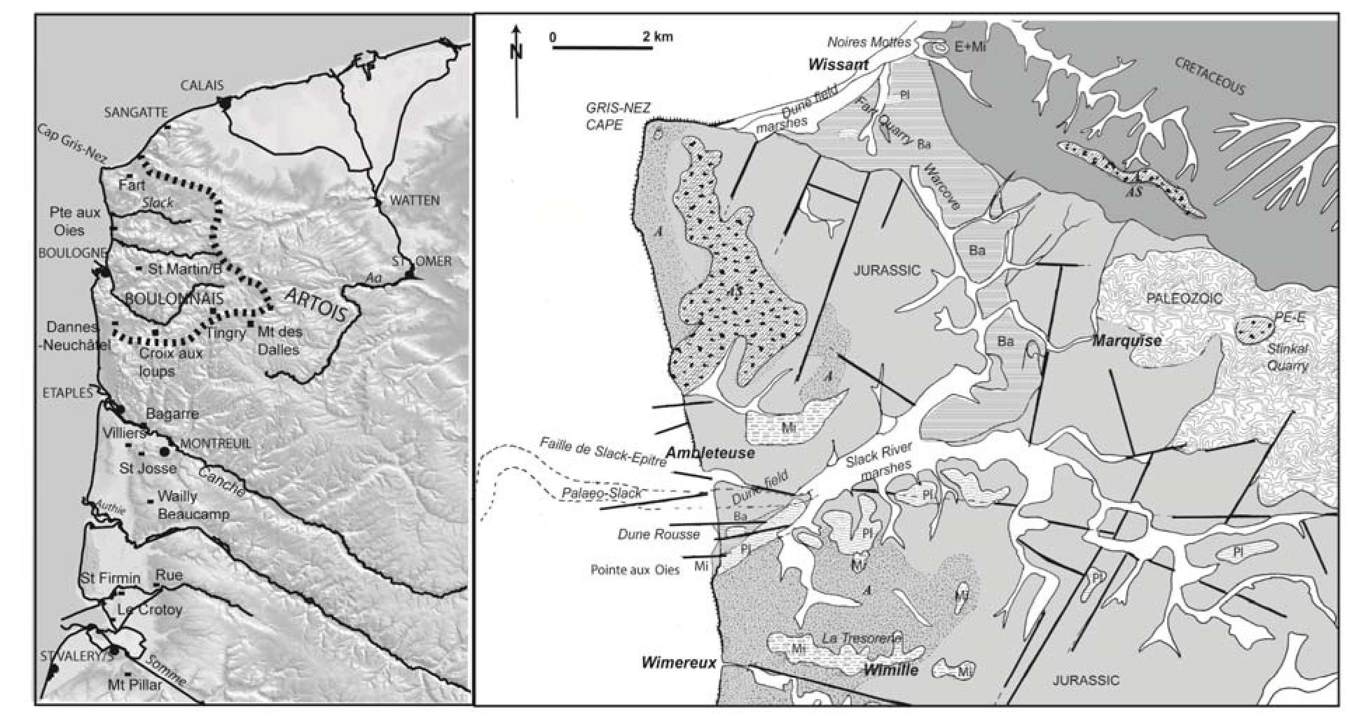
Localisation of the sites (stipple line: the paleo-cliff) and maps of the Cenozoic deposits. The Quaternary is not mentioned. A: saprolite; AS: clay with flints; PE-E Thanetian-Sparnacian; Ba: Bartonian; Mi: Upper Miocene; Pi: Middle Pliocene.
Localisation des sites et carte des formations cénozoïques. Le Quaternaire n'est pas pris en compte.
Figure 5
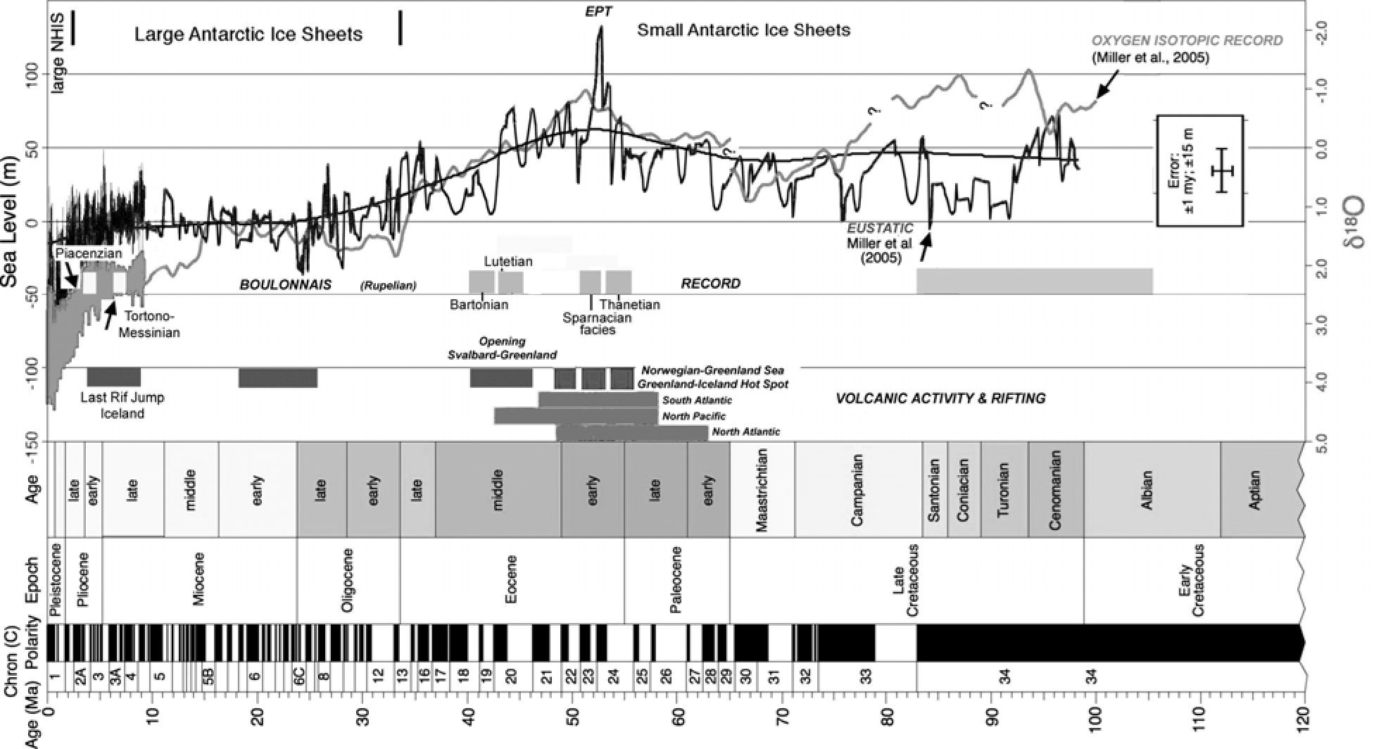
Eustatic curve for the Cretaceaous and the whole Cenozoic. Modified and completed from Miller et al. (2005).
Courbe eustatique pour le Crétacé et le Cénozoique. Modifiée et complétée de Miller et al. (2005).
This period close to 52 Ma is the sudden maximum achieved by the eustatic curve (+ 135 m; Miller et al., 2005; + 230 m in Haq et al., 1987; + 260 m in Hardenbol et al., 1998), just after the thermal event of the “Paleocene-Eocene” transition (PETM: 58,5 Ma) (fig.5). It corresponds to the main period of opening of the Atlantic Ocean between Norway and Greenland and the formation of the Greenland basalts (62-59 Ma, 57-54 Ma and 50-47 Ma, Courtillot & Renne, 2003) but also volcanic activities in the other oceans.
At the level of the regional stresses, the regime is mostly meridian (Bergerat & Vandycke, 1994). The available space for the sedimentation, allows important deposits in the Wessex and in the North Sea basins. Compared with the Paleogene of the Isle of Wight, the Ypresian to Bartonian beds are widely spread and folded (synthesis in Curry, 1992). Also in the sector of North Hinder, located offshore of Oostend on a NW-SE flexure (fig. 3), a reactivation of tilted blocks deforms the Thanetian sands and also folds the Ypresian clays (Henriet et al., 1989). At that time the European rift forms (Nadin et al., 1995; Lepercq & Gaulier, 1996). Later, the sea level quickly falls.
The interest of this interpretation is to position at the beginning of the late Ypresian the erosion of the Boulonnais down to its main surface (+110 / +90 m), commonly down to the base of the Cretaceous. This surface apparently polygenetic is widely extended inside the Boulonnais and also in the Weald, where it is deformed. It develops in the South of the valley of Slack, more particularly at the East of Boulogne (fig. 4) and at the foot of the internal paleo-cliff. This surface represents a flat-bottomed gulf bordered by a marine paleo-cliff controlled by faults. It is generally covered to the West with a gently sloping pediment covered with flints. The surface truncates the summit (c.+ 140 m) of the Cap Blanc-Nez where it is covered by the lower Eocene of Noires Mottes hills. This "Cuisian" facies is preserved within the Boulonnais in karst depressions (Stinkal quarry) and in paleo-valleys protected from the erosion by a fault's offset. The presence of hydromorphic tropical paleosols (Ecuelle Trouée, St Martin-de-Boulogne) with local silicification (opale; Croix-aux-Loups, close to Verlicthun) would position one of the episodes of silicification at the end of Ypresian. Also the facies "Cuisian" of the Oise River valley presents such silicifications. These silicifications are induced by an exondation with a reactivation of the already sketched E-W river system.
A reappraisal of middle Wimille Beds: a residual Lutetian?
The middle Wimille Beds crop out discretely on the Lower Wimille Beds (fig. 6). It is constituted by clays and fine sands with bioturbations or more gravely including small pebbles of filonian quartz and of flint, fining in an ochreous sandy silt (> 2m) with thin hydromorphic paleosols (swamp or schorre with tidal invasions); it is further truncated by a sandy level with gravels. The faunal content is not preserved. It crops out at Wimille as eastward of St Martin-de-Boulogne. This facies also corresponds to the uppermost facies of the "Cuisian" of the Mount Hulin (Dubois, 1921; Destombes & Lapierre, 1974) but is not preserved at the Noires Mottes hills. The middle Wimille Beds seem equivalent to the silicified Lutetian of Belgium and the Mont des Recollets at Cassel (Ledian sands). In Belgium, Lutetian sands of Brussels and of Lede contain early siliceous consolidations (probably ante-Oligocene) connected with the uplift of the Variscan front.
The middle Wimille Beds could be thus attributed roughly to the Lutetian. The absence of this facies at the base of the Noires Mottes hills and along the north edge of the Weald confirms a tectonic activity at the level of the north flexure of the basin. G.Waterlot (1969) already placed the uplift of Artois at the end of Middle Eocene. The dome of Artois has the reputation to be widely submerged (Pomerol, 2005), but the main surface into the Boulonnais seems partly emerged only. During the upper Lutetian time, the regression begins, enhancing river incision.
A reappraisal of the lower Slack Beds: a sandy clayish Bartonian? (fig. 6)
Formerly attributed to the Quaternary (de Heinzelin, 1964; Bonte & de Heinzelin, 1967; de Heinzelin, 1967), we had reinterpreted these beds preserved below the Dune Rousse, north of the Pointes-aux-Oies (Wimereux, fig. 4) as being potentially lower Pliocene in age (Van Vliet-Lanoë et al., 1998). This formation rests on a low surface occupying the valley of Warcove and the low valley of Slack, isolating the Island of the Cap Gris-Nez. It is fully disconnected from the Wimille Beds. The strait is probably already open.
The lower Slack Beds consists in two units: the upper, is formed by 8 m of fine sands with ripple marks capped by rhythmic grey brownish clays, more pinkish to the top, with basal and intra-formational involutions, comparable to slumps and load casts. These sands incise a 10 to 12 m lower bed formed by the "argiles à biscuits", an alternation of pinkish grey silts and clays layers with flat carbonated concretions. Northward, the base of this unit presents an alternation of sands and littoral silt with ripple marks. It is a quiet sedimentation in a lagoon, with temporary tidal incursions. This formation does not contain Neogene nor Pleistocene foraminifers or fauna. The sandy facies reworks essentially microfossils issued from the Cenomanian, Turonnian and Santonian chalks. The upper unit reworks a fauna essentially of basal middle Coniacian (C.Bourdillon, ERADATA report 2008). The basal gravel of the section described by the various authors is protected on a drag fold of an E-W fault (Slack-Epitre fault), at the North of the section. It is a conglomerate consisting of decimetre-sized pebbles of flint and sandstone in a grey-greenish non-calcareous sandy matrix. No microfauna is preserved other than meaningless shells fragments (oysters). It corresponds to an upper beach, further drowned by lagoon sedimentation. This whole formation constitutes a faulted block tilted to the south in association with figures of slump and liquefaction.
In the gravel pit of Wissant, the equivalent of the lower Slack Beds (de Heinzelin, 1964) rests locally on Aptian sands. It consists in thinly stratified grey-pink clay interbedded by grey-greenish glauconitic sand, with irregular syn-sedimentary "cryoturbations" (Roep et al., 1975). South of the Warcove depression, Paleozoic pebbles were observed within clays of the lower Slack, indicating a flow or a drift towards the N-W according to the erosion of the Paleozoic basement in the Marquise's sector. This is paradoxical with the observations of Roep et al., 1975. These beds are faulted and cut in blocks according to the Marquise's new geologic map (Mansy et al., 2002). These beds may reach up to 30 m at Warcove (drilling). The lower Slack Beds mostly copies the Upper Barton Beds of Friars cliffs near Highcliffe (East of Bournemouth) with subunits equating Friars beds A3, B, C and D rich in calcareous septa (the “biscuits”) (Curry et al., 1969, - 1975; Curry, 1992). In the Northern Warcove, under these same clays, Lefèvre and Sommé (2001) observed in drilling darker grey clays with at there base the "sables de Bélina", a shelly oxidized sandy facies, thick of 7 m, considered as Quaternary. This sedimentary record developing below the Lower Slack formation is similar to the Barton sands of the Wessex (Curry et al., 1969, - 1975, Curry 1992; Denizot, 1968). The lagoon aggradation at the Slack formation could correspond to extensive Bartonian as it occupies as well the Warcove valley and the estuary of the Slack River, but also occurs south of the Boulonnais, close to the Canche River as a similar grey-pink clay was observed in drilling resting on the Thanetian / Ypresian at Villiers (Canche River).
The widespread extent of the Bartonian (40 - 37 Ma) in the Wessex-Wight basin should consolidate this interpretation. The Bartonian is folded on the Northern slope of the Isle of Wight. In the sector of Highcliffe, Bartonian is affected by co-seismic synsedimentary deformations (West, 2010) and its lower facies are grey clays, often truncated directly by the Mio-Pliocene (“Quaternary”) deposits. This is also the case for Slack (see further). In Belgium, the Bartonian is also tilted (Vandenberghe et al., 2004).
At the regional scale, this possible Bartonian and its Ypresian basement show a 40 m offset controlled by N50 faults between the drilling at Villiers and the outcrops of St-Josse-Montreuil. This observation corresponds very well to the late deformations observed on the Isle of Wight (Curry et al., 1975) and at the Pointe-aux-Oies. It corresponds to the main phase of tectonic inversion, synchronous with the Pyrenean orogen, already recognized for the Celtic domain and the Western Approaches of the English Channel (Ziegler, 1990). In the English Channel, the Middle Eocene, unlike the lower one, records differential accommodations giving evidences of a synsedimentary tectonic activity. The Boulonnais is uplifted, easing the incision of the river system and the dismantling of the Paleogene saprolites developed in the Upper Cretaceous chalks. For Curry (1992), the strait seems open during the very late Eocene and the lowest Oligocene.
The Oligocene and the Rupelian
Because its low altitude (+8 to +30m), another possible interpretation of the rhytmites clays of the upper part of the lower Slack Beds could be a continental Rupelian facies. No argument allows to assert or to counter this hypothesis, Rupelian being extensive at the North of the strait (Clays of Boom ; Vandenberghe et al., 2004; King, 2006), where the rythmicity follows the Milankovitch cycles (Vandenberghe et al., 2004)
The whole axis Weald-Boulonnais would be, according to the published data (Ziegler, 1990), emerged during the Oligocene (lack of preserved deposits) due to a renewed inversion, but with an open strait from the middle Eocene, the river system certainly exploited the former strait. Published paleogeographic maps of the Oligocene (Pomerol, 1973) localize a continental barrier at the level of the strait, in spite of the quasi-identical character of lower Rupelian of the facies of the Isle of Wight and Tongeren (Van Simaeys and Vandenberghe, 2006). The strait is thus open during the Bartonian, probably still open at the beginning of Rupelian (c.32 Ma,) as a result of the E-W extension phase of the Oligocene, related with the major activity of the European rift. This phase enabled a late opening of the strait before the deep regression of the Chattian (24 Ma). Downstream of the English Channel the Oligocene Jones Formation incises the Eocene at the base of the Western Approaches (Evans & Huges, 1980) probably recording the end of the uplift of the Boulonnais and the Bray high. In the same time, a regression due to the opening of the Atlantic Ocean in the North of Iceland and to the building of the first Antarctic ice sheet (38 Ma, Ziegler, 1992; Abreu et al., 1998). Its impact on the Boulonnais and the Weald allows with the inversion the reactivation of the weathering and the continuation of the erosion. The Strait of Dover probably disappeared, in the late Oligocene, remaining closed during most of the Miocene, due to the impact of the Alpine orogen. The strait is transformed in a major valley system flowing to the south, due to the southward tilting of the reactivated Varsican overthrust.
2) The Neogene
The Neogene is not yet recognized in the Weald, the Lehnam Beds (+180 m) excepted. There faunal content of these beds has been attributed in fine to the upper Miocene (Cooper 1980; Balson 1989, King 2006) as also for the Monts des Flandres (Formation of Diest; Vandenberghe et al., 1998). Both mark a coastline (Desoignies and Thibaut, 1968; Pomerol, 1973; Balson, 1989; Curry, 1992). In Belgium, the formation of Diest covers both the Tortonian and the very early Messinian and form sand banks parallel to the paleo-coast (Vandenberghe et al., 1998). The strait seems close according to the last data obtained by Dinoflagellates stratigraphy (Louwye & Laga, 2008) in opposition with Margerel (1989) observations on foraminifers. Large coastal gravels ridges existed on both side of the strait, attesting with the sand banks of high energy. It drifted W-E from the Noires Mottes to Leuven in Belgium, with a mineralogy reworking Nordic and Ardennes elements (Van Vliet-Lanoë et al., 2002; Vandenberghe et al., 2004) and from Aldershot to Lehnam (UK), probably crossing the strait. A late Tortonien-early Messinien (c. 7 Ma) was also recognized at Fécamp (Mercier et al., 1997).
The Tortono-Messinian: the upper Wimille and Wimereux Beds
The beds of the Noires Mottes (+150m), the last “Monts des Flandres”, rarely in situ, consist in a stratified ferruginous conglomerate with a sandy matrix cemented by goethite; its thickness never exceeds 5 m. It reworks pebbles of flint, Eocene silicifications and filonian quartz; it is rich in glauconite and sometimes preserves moulds of shells. The mineralogy of the sand fraction is reworked from Nordic and S.Ardennes sources (Van Vliet-Lanoë et al., 2002).
Figure 6
Compound stratigraphical log of the Cenozoic stratigraphy in the Boulonnais. Modified from Van Vliet-Lanoë et al. (1998).
Log stratigraphique composite des formations cénozoiques du Boulonnais. Modifiée par Van Vliet-Lanoë et al. (1998).
Another facies appears in an extensive way as well to Wimille (La Trésorerie) as in unconformity on a silcrete at the top of the quarry of the Croix-du-Loup (Verlincthun) or as south of Boulogne, eroding the Jurassic under the Holocene dune field. The upper Wimille Beds mostly crops out at the East of Boulogne (St Martin-de-Boulogne: Mont de Joie) at the Warenne d'Ecault and at Wimille (Mont Boisé, La Trésorerie) filling a network of shallow paleo-valleys in connection with a fault N150 up to +90 m. These Wimille Beds consist in green fine sand (up to 3 m), stratified (2D dunes) including grains of milky quartz and volcanic minerals, interstratified with clayish, sometimes organic, fine beds (wood); the neoformed glauconite is abundant. These green sands correspond to a facies of tidal channel with shell moulds, further weathered by a red yellow podsolic soil and a goethite iron pan. Compared with the Noires Mottes conglomerate, it evidences another source of sediments originating from the eastern border of the Paris basin, via the Paleo-Somme River (Van Vliet-Lanoë et al., 1998). The bottom of the dry valley of Dannes-Neuchâtel (+ 66 m) is filled in the North with 12 m of clayey sands, rich in flint red (Bonte et al., 1985) which is well similar with the upper Wimille Beds. These Wimille Beds are younger than the early Oligocene (silcrete) and seems very similar to the Diest formation of Diest, but in an environment corresponding to a shallow embaymenent. The strait remains closed.
At lower altitude (+ 8 m, subsiding western coastal panel), at the base of the cliff in the Pointe-aux-Oies sensu-stricto, an marine abrasion surface, highly weathered by a cryptokarst, is covered by 2 m of poorly sorted heterolithic conglomerate (pebbles to boulders), characterized by a thick goethite cortex (cm thick). It forms the Wimereux Beds. This conglomerate is sealed by goethite and is somewhat younger than the upper Wimille Beds. These pebbles are surmounted by 4 m of sands of the upper Slack Beds, Piacenzian in age. These pebbles are also splayed at the surface, south of the Strait of Dover. Given the amplitude of the glacial forcing at that time (40 m, Abreu et al, 1998), it is possible that the upper Wimille Beds represents a interglacial high stand and that of Wimereux a "glacial" low stand (Van Vliet-Lanoë et al., 2002). It is indeed the time when the large ice sheets as those of Antarctica and that of Greenland formed (fig. 4). A dating obtained in a similar context at Pénestin (estuary of the Vilaine River, Brittany) yielded an age of 6,7 Ma (Van Vliet-Lanoë et al., 2009) and a Messinian low stand with anchored ice dynamics, fitting the cooling recorded by Louwye & Laga (2008) in the Kasterlee Beds in Belgium.
Deformations and tectonic activities are recorded. In the South of the Boulonnais, the Wimille Beds are preserved on a surface reaching + 60 m (Samer, Verlicthun) connected with the pass of Dannes-Neuchâtel (+ 80 m). This surface can be followed in the North from La Pointe-aux-Oies to Wissant (+ 56 m) and along the left bank of Slack River, apparently tilted southward at the North of the River. On the Gris-Nez cape, it is developed between + 60 and + 50 m. The conservation of these beds is strongly controlled by the faults of Slack-Epitre and of Wimereux-Belle (block tilting) (Mansy et al., 2001). In opposition, the Noires Mottes (+150m) are lifted up relatively by about 20 m, in connection with the activity of the flexure of Sangatte. A vertical offset of 20-30 m lowers the paleo-surface and reveals some subsidence on the eastern side of the strait, due to a faulting in parallel with the coast; it can be observed between Terlinctun - la Poterie (+55 m) and St Martin de Boulogne (+90 m) and at the level of Les-Garennes-de-Wimille (+ 63 m) and la Trésorerie (+ 84 m). This Wimille Beds is microfaulted in dextral strikeslip N150, synchronous of the end of its deposition and displaced by meridian faults. The phase of weathering with the goethite pan seals the tectonic movements and the valley incision. It is also the time of the Savian tectonic phase (“Messinian Crisis”) and of a major rift jump in Iceland (8-3 Ma, Garcia et al., 2003).
The middle Pliocene of the “Dune Rousse” or the upper Slack Beds (fig. 6)
At the North of the Pointe-aux-Oies (+5 to +25m), yellow-red sands crop out below the recent dune and an upper conglomerate, a terrace Pleistocene in age. At their base, a thick conglomerate, 3 to 5 m thick, reworks flint and also an important proportion of angular blocks issued from Marquise's Paleozoic; it incises the Lower Slack Beds. It is covered by a series of 3D sandy bars, prograding northward, locally deformed by structures of sliding (recumbent folds) (Van Vliet-Lanoë et al., 1998). It represents an ancient river channel evolving upward to a tidal facies. They are protected in a graben under the Flandrian (Slack River marshes). These beds also exist in the south of the Warcove depression and locally in the quarry “du Fart” at Wissant according to de Heinzelin (1964) and Roep et al., (1975). In the quarry of Wissant, these sandy bars evolve in system of bars and scours (2D dunes) also incising the Lower Slack Beds (Van Vliet-Lanoë et al., 1998). In the Warcove, the red sands can achieve 10.5 m, 18 - 20m in the South of the Fart's quarry forming a terrace noted Q2S by Lefèvre and Sommé (2001). They constitute according to us the track of a tidal channel, flowing from Wissant to Ambleteuse and belonging to the upper Slack Beds. This complex may reach near +35 m in altitude.
A dating of 3,67 ± 0,52 Ma was obtained by ESR on the Red Sands'base (Van Vliet-Lanoë et al., 2004), which places these beds in the same stratigraphical position that the sands of Kruischans and the Poederlee formation in Belgium (Vandenberghe et al., 1998; Louwye & De Schepperes, 2010), and the base of Piacenzian (sequence Za2-Pia1, Hardenbol et al., 1998). The facies " Red Sands " in the Boulonnais is comparable to Pliocene " Red Sands " of the Forest of Clairmarais (Desoignies & Thibaut, 1968), white sandy facies with mega-ripples, evolving into tidal facies in the quarry of La Pyramide at Helfaux (+ 60 m, fig. 5), in the quarries of Montreuil (+50 m, valley of Canche River) and in the ancient plateau gravel's pits of Wailly-Beaucamp (+ 43 m, Authie River). All those beds constitute extensive thin estuarine splays truncating the Eocene like at St Valéry-surSomme (+ 43 m).
Malacofauna and micropaleontological analysis in the North Sea basin prove the persistence of an open strait with as today a Northward tide current along the French side of the strait until 1,79 Ma (end of the Pre-Tiglian; Meijer & Preece, 1995).
3) The Quaternary (< 2,6 Ma)
The Lower Quaternary: the Fart Beds (Wissant's gravel pit,)
It corresponds to a paleo-estuary of the Warcove (de Heinzelin, 1964) from which the base reaches -15 m. It consists in a poorly sorted and frost shattered conglomerate of mixed ochreous and fresh flints, reworking faunal remains of the lower Pleistocene (Hippotamus major, Elephas meridionnalis) and glacial erratic from Scandinavia (syenite, granite, dolerite, Paleozoic sandstone, silicified stem of Paleocene palm tree). This unit crops northward out up to + 13 m, and is covered by heads and loess. It corresponds to an estuarian complex attributed to the Cromerian s.l. (800 to 480 ka; de Heinzelin, 1967), incising the Aptian and the upper and lower Slack beds. According to the faunal contents, following Jones and Keen (1993), it would rather be an estuary from the Waalian to Eburonian (1,5 to 1,4 Ma). It is possible that the Fart Beds could also be subsynchron of the lower Pleistocene of the Somme estuary, yielding 1,8 Ma (Mt Pillar, Laurent et al., 1998), here in a low stand facies. The Fart Beds could be the first testimony of the strait Quaternary closure at 1,79 Ma (Meijer & Preece, 1995).
These Fart Beds also crop out south of the Boulonnais in the form of raised beach ridges armouring the Picardy plain. It forms a series of polygenetic beach ridges from which the final term is contemporary of the Sangatte Beds and of the Canche Beds. In the gravel pits of Rue-St Firmin, a lower Pleistocene fauna was also observed with Paleogene silicifications and erratic boulders (Dubois, 1924) derived from Cornwall or Armorican massifs (dolerite, diorite).
The Middle Pleistocene Beds of Sangatte
These Beds are deposited on a marine abrasion surface (+5 to +8 m) which is located at the northern part of the flexure of Sangatte (Mansy et al., 2001). The beds are surveyed by us since 1968.
On a deeply frost shattered platform, a regressive gravely beach was formed in cold conditions (shore ice activity; Van Vliet-Lanoë et al., 2004), as also proved by the presence of a boreal malacofauna described by Lighter (1924, in Sommé et al., 1999). This first shore deposit corresponds to the unit B of Balescu and Lamothe (1993) and to the units 12c-12g of Antoine (1989). Sommé et al., 1999 attribute it to the “Holstenian” (attributed to “MIS 9” instead of Holstenian = MIS 11) by analogy with the lower Herzeele Beds which yield 280-300 ka. A recent dating by ESR of the lower Sangatte beach yielded an age of 282 ± 25 ka BP (late MIS 9; Van Vliet-Lanoë et al., 2004), as in other similar position along Brittany, Cornwall and southern England as also Flanders (Van Vliet-Lanoë et al., 2000). This paleo-beach is buried by rock fall and solifluction before being incised by a new fossil cliff. A second beach (green sands with some gravels) reaches + 6 m. It has been dated at 200 et 229 ka by thermo-luminescence (MIS 7; unit C of Balescu & Lamothe, 1993). The two beaches are sometimes observed in overlapping. This second beach is covered by loess and slopes deposits including periglacial soils, co-seismic and tectonic flowers deformations (Van Vliet-Lanoë et al., 2004).
The old loesses were dated by TL to MIS 6 by Balescu et al. (1984). By analogy with similar and dated littoral sequences, the loessic sedimentation developed between 160 and 140 ka (Loyer et al., 1995). At the top of this loessic complex, a thick weathering with solution pipes develops synchronously with the Last Interglacial period (MIS 5e: 130-110 ka; Sommé, 1977; Balescu et al., 1984). Slope deposits of the Last Glacial period, a late glacial pedogenesis and limited slope deposits of the Younger Dryas are observed although attributed to the whole Weichselian by Antoine, 1989.
This Sangatte Beds thus covers MIS 9-8-7-6-5 and the Last Glacial period. The most important erosion occurs during the MIS 6. The late MIS 9 beach and the recent one are rich in flints and the Eemian beach (MIS 5e) is not cropping out directly at the north of the flexure, at Coquelles excepted. A normal fault activity of the flexure exists at c.160 ka (Van Vliet-Lanoë et al., 2004): the Eemian pedocomplex and MIS 6 and 7 deposits are deformed by 3 nearby faults with a vertical offset of at least 2 m. All the tectonic deformations cumulated on the Sangatte section represent an offset of at least 6 m of the sector since 200 ka (Van Vliet-Lanoë et al., 2004). The opening of the strait is attested in the loesses of the MIS 6 cropping in the cliff. Their mineralogical composition is wider than for the earlier loesses (Balescu et al., 1984) and gets closer to these of the recent loesses marked by an important Scandinavian influence. This opening could take place towards 160 ka in relation with an activity of the flexure lowering the northern compartment of the strait.
The Eemian beds of the Canche River: new data
Specific beds were observed by drilling in the estuary of Canche River and recognized on the whole Picardy maritime plain. It consists in 2 units related with the raised beach ridges of the Picardy plain (Gosselin; PhD in preparation). The lower unit consists in a decalcified tidal muddy formation, covered by oxidized sands. The second unit consists in sands and grinds (white flint fragments) commonly decalcified. Near the mouth of Canche only, this upper member was reached at a depth of - 30m by drilling, reworking shells (Cerastoma edule; Meurisse, 2008). On the western face of the Crotoy raised beach ridge, this formation is followed by weathered dune sands, often cryoturbated. It belongs to the maximal high stand (MFS) of a former interglacial older than the last glaciation because it is covered by Preboreal (14C dating) and older peats near Rue village (Ters et al., 1980), and loessic deposits near the Authie river. It can be considered as Eemian as stressed by Edmondspöl (1993) and probably synchronic with the late activity of the raised beach at Coquelles (Sommé, 1977, - et al., 1999), at Loon and Watten (Sommé, 1979; Sommé et al., 1994), at the Ply-de- Camiers (Canche River estuary; Gosselin, 2007) and in Picardy at Bagarre (Tuffreau et al., 1975) or in the Villiers - St Firmin - Crotoy raised beaches.
The Flandrian: a reappraisal
A complete re-analysis of the littoral prism and the estuarien Holocene was undertaken within the framework of several recent PhD (Gandouin, 2003; Meurisse-Fort, 2008; Gosselin, PhD in preparation). The Flandrian Beds are commonly subdivided into 2: the Calais and the Dunkirk beds (Dubois, 1924; Sommé, 1977). The Holocene transgression reached very early from the South the entrance of the St Omer's basin (towards 8500 BP), inducing the formation of the basal peat (Preboreal), in this subsident sector at the foot of the Artois' flexure (Gandouin et al., 2007). The transgression rose very quickly to 7000 BP (Melt Water pulses Id) to achieve c. 1 m 50 above the current HWM towards 6000 BP (Meurisse-Fort, 2008): it is the maximal surface of flooding (MFS). Estuaries are invaded by tidal mud flats high upstream from the current coast line. This true interglacial transgression corresponds to the former “Calais beds”, whereas gravely beach ridges formed at the foot of cliff along the Picardy plain, as at Villiers and along the northern cliff of Boulonnais between + 5 and + 9 m (Coulogne; Sommé, 1977; - et al., 1999).
This maximum is followed by a marked regression down to -8 m (-12 m for the lower intertidal zone) in the estuary of Canche River (Gosselin, 2007; Meurisse, 2008) and -6 m at the entrance of the basin of St Omer at Watten (Gandouin et al., 2007). It corresponds to the Subboreal regression (c.5500 BP); this regression occurred in absence of regressive dunes on the Belgian and Picardy coasts (Meurisse et al., 2009). The first coastal dunes' development due to the impact of the storms formed c. 3000 BP. Towards 300 AD, a climate cooling associated with an increased storminess and floods on land led to the construction of the Older Dunes, during the Merovingian cooling (Meurisse et al., 2005). The Young Dunes retrimmed the Older one during the Little Ice Age cooling, also in connection with an increased storminess. It is also the period when the low beach ridges of the Calais maritime plain developed (Sommé, 1977). In fact, the “beds” of Dunkirk mostly consist in repeated flooding due to storm's frequency rather than a true transgression: the eustatic level is globally slightly regressive. These pseudo-transgressions were facilitated by the compaction of the previous beds, mostly during the Subboreal regression (Gandouin, 2003; Meurisse, 2008).
IV. — The North Sea - eastern English Channel connections
The English Channel is characterized by an extended marine abrasion surface, locally superimposed on much older surfaces of Mesozoic or Permian ages (Hamblin et al., 1992). Since the late Paleogene, the sea level is controlled by a progressive lowering connected with sea floor spreading and ice cap building, especially since 38 Ma, with several accelerated steps at 11; 5,9; 2,4; 1-0,8 and 0,4-3 Ma (Abreu et al., 1998) but it may be also forced by a hotspot bulging as the Greenland-Iceland one. Several eustatic curves where reconstructed from the sedimentary record in “stables” regions (Haq et al., 1988; Abreu et al., 1998; Miller et al., 2005), in connection with the isotopic curves. For Quaternarists, the strait opening, the river incision and the terraces are classically considered as controlled by glacio-eustatism and recently with some tectonic component responsible for a hypothetic Pliocene uplift (eg. Antoine et al., 2007). During Quaternary, glacio-isostatic deformation may also have modified the river base level. Correlative to the tectonic movements controlling the transgression and sedimentation patterns, river and karst networks may trace the succession of tectonic events.
Figure 7
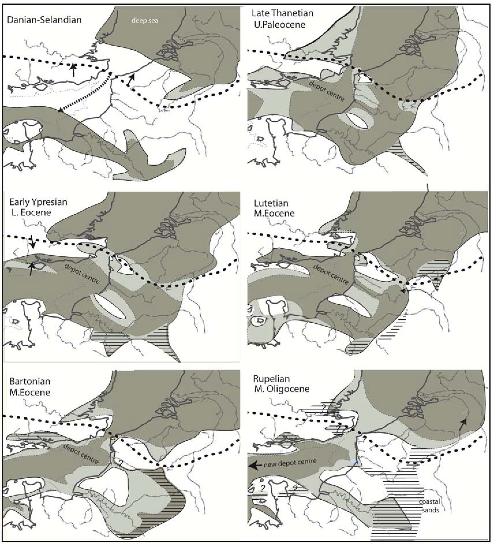
Paleogeographic Reconstruction of the Strait of Dover during the Paleogene. The data from Hamblin et al. (1992), Pomerol (1993) and King (2006) are constrained by the regional structural control and our new data. Stippled line: Variscan deformation front. The horizontal lines represent lagoonal to lacustrine facies, light grey : shallow sea.
Reconstitution de la paléogéographie du détroit du Pas-de-Calais pendant le Paléogène. Données de Hamblin et al. (1992), Pomerol (1993) et King (2006), contraintes par le contexte structural régional et nos nouvelles données.
1) The discrete openings of the Strait
Sediment record on the Boulonnais is continuous from the late lower Jurassic to the Cenomanian. After, sedimentation is more discontinuous, shallower during the Turonnian and ends with the Santonian (Mansy et al., 2002). The Weald-Boulonnais antiform emerges with the Laramian tectonic phase and a limited regression interpreted as limited glaciation on Antarctica (Miller et al., 2005; fig. 4). We have also seen that the excavation of the Boulonnais began already during the Paleocene, from the South through the Tingry pass, allowing the deposition of Ypresian sands (end of the high stand of the PETM complex, fig. 5). The strait seems open from the late Ypresian prior to the deposition of the Lower Slack Beds. It seems thus that the Boulonnais morphology with the paleo-cliff and the main surface was already incised by about 80 m probably during the Thanetian (low stands), as a result from the post-Laramian tectonic relaxation. The E-W Slack and N-S Warcove valleys initiated probably during the brief regression events after the PETM, especially at the end of the “Sparnacian-Cuisien facies”(56-50 Ma).
The strait is also open from the Middle Eocene as stressed by Ziegler 1990, as Middle Eocene Thetys fauna reaches the North Sea until the Rupelian (Van Simaeys & Vandenberghe, 2006). In fact the sedimentary record is nearly continuous on the Boulonnais zone and surroundings, controlled by the rapid high stands succession as described by the eustatic curve by Miller et al., (2005; fig. 4). As the strait exists, tidal currents may during high stands enhance the valley systems incised during the Laramian uplift. As the compression stress field is meridian, valleys use as well W-E faults and folds as N-S faults.
Afterwards, the strait is closed from the late Oligocene to the Tortonian with the Alpine tectonic phase, briefly open from 3,7 Ma to 1,79 Ma and re-open from c.160 ka. During the Eemian (MIS 5e: 130-110 ka), the Strait reached its present width, probably from the re-excavation of the pre-existing Mio-Pliocene Lobourg Deep. Its opening was made easier by its soft sedimentary infilling (beach gravel ridge included), caused by potential stronger tidal currents (Scourse & Austin, 1995) related to high stands up to + 6 m above the Holocene MFS. Only scarce occurrence of the Eemian exists in the eastern English Channel, on the coast of Sussex (White, 1915). In another hand, the low biodiversity of the southern North Sea prior to the Eemian (Meijer & Preece, 1995) attests more for an embayment with tidal flats limited to the south by a raised beach ridge, an image coherent with Tesch (1939) observations. This was located on the main flexure and anchored on the Cap Gris-Nez and Dungeness. An opening of the strait seems also rather difficult for tectonic reasons (Van Vliet-Lanoë et al., 2002). The zone of the strait is uplifted minimum by probably 50 m, due to the Middle Quaternary tectonic event (c.600 to c.280 ka).
2) The Fosses Dangeard
A main characteristic of the strait is the existence of the “Fosses Dangeard” parallel with the main flexure of the Variscan overthrust (Destombes et al., 1975). These deeps correspond to a series of W-E small dextral pull apart basins, exploited by rivers during emersions and scoured by tidal currents during transgressions. It results from the crossing of the N 120 structural direction from the Weald and the E-W direction from the Boulonnais (fig. 3). A seismic campaign performed in 2002 allowed to determine a complex valley system in the eastern part of the “Fosses Dangeard”. Five main valley systems were determined (fig. 9; Delestret, 2004). The oldest system, initiated during the Laramian emersion may thus be excavated and filled from the onset of the Eocene (D1), as discussed higher. The second valley system presents a late drainage to the south during the second and major uplift of the Variscan front and it's southward tilting; it means that the second generation of infilling (D2) (fig. 8) should correspond to the Middle-Upper Eocene (Lutetian and Bartonian), deformed by the Pyrenean Orogen. Several incisions in the chalk along the Picardy coast are filled with these formation (Gosselin, PhD in preparation). As the strait remained open to the lower Rupelian, the North-South incision was probably exaggerated by tidal currents, accumulating the third generation of infill (D3) during the Rupelian (eg. clay of Boom, in Belgium). D3 is further incised by fluvial incision from the Chattian as stressed by Jones (1990) to the West. The Lobourg channel (fig.8) crosscuts this system and is probably inherited from the uplift of the front synchronic with the Alpine orogen (late Oligocene phase) and filled with Neogene fluvial terraces (D4) as proposed by several authors (Dingwall, 1975; Bridgland & D'Olier, 1995; Van Vliet-Lanoë et al., 2004). D5 corresponds to the Pleistocene system (Delestret, 2004). During late Tortonian / Messinian, the Strait of Dover remains closed (Margerel, 1998; Van Vliet-Lanoë et al, 1998; Louwye & Laga, 2008). Huge gravel or sand bars follow the coasts. Evidence of vertical offset, oriented N-S is recorded in the western Boulonnais, disconnecting the valley system of the Boulonnais from these of the Fosses Dangeard. This vertical displacement is sealed by the Middle Pliocene Red Sands of the Slack estuary.
3) The palaeo-valley systems (Fig. 8)
The tectonic control
The whole English Channel is characterised by extended abrasion platforms, imperfect and polygenetic on which palaeo-valleys systems are carved. The platforms truncate folds in Jurassic and Cretaceous rocks on the English side and the Boulonnais coast. The southern boundary of the area, including southern Brittany, the entrance of the Channel, Cornwall and Scillies belongs to the Western Approaches of the Channel system and is subsiding by steps as a passive margin and as a side of the Western Channel “graben” since the opening of the Biscay gulf (Evans, 1990) from the early Cretaceous. Southward tilting in the vicinity of the Variscan front is also proved, by the drowning of Cornwall and Western Brittany rias and by the drowning of the paleo-cliff along the southern coast of England (Van Vliet-Lanoë et al., 1998, et al., 2002). Global pulsed tectonic events were recognized by Sheridan (1987) for the Paleozoic and Mesozoic. A similar pulsed system exists during the Cenozoic, in association with long wave length deformations (de Lugt et al., 2003; Van Vliet-Lanoë et al., 2002, 2004; Wyns, 1991). The sedimentary gap from the late Oligocene to the middle Miocene in the Boulonnais records the Alpine tectonic phases and a long phase of emersion. In Belgium, the Miocene cryptokarst of Condroz described by Dupuis (1992) is mainly synchronic with the late middle Miocene and of the late upper Miocene tectonic uplift events.
The English Channel and Southern North Sea platforms
The Channel platform was excavated by marine abrasion as well as also the main paleo-cliffs. These cliffs are cropping out along the Picardy coast although drowned and tilted along the Southern Britain coast, Western Brittany and Northern Cotentin (fig. 8). The first abrasion surface is located at the base of the Jones formation in the Western Approaches (WA) (Evans, 1990) which now records most of the late Oligocene to the end of the Serravalian (Le Roy et al., submitted) also correlative with the Alpine orogen, and the events on the Northern Mid Atlantic Ridge (Géli, 1993). These successive marine abrasion surfaces formed mostly during low stands, boosted since the upper Miocene by sea ice abrasion (Van Vliet-Lanoë et al., 2002; -2009). This chronology seems also valid for the Hamphsire-Dieppe basin (HDB) as the Paleogene is truncated by the main surface. One of these erosion surface in the WA is recorded by the occurrence of an unconformity at the base of the Cockburn Formation (Evans 1990), formation which constitutes a prograding submarine fan dated roughly from the base of the Tortonian to the Late Piacenzian (Le Roy et al., submitted). A similar situation prevailed during younger lowstands in the WA as Late Pliocene incisions (Gelasian) are truncated by such a surface close to the platform edge (Le Roy et al., submitted). To the South-West, the last major incision connected to this surface has been also dated on land to the base of the Tortonian by ESR (Laurent et al. 1998 ; Van Vliet-Lanoë et al., 2002; Van Vliet-Lanoë et al., 2009; Paquet et al., 2010).
The Southern North Sea (SNSE) embayment is marked by a shallow abrasion surface truncating the Thanetian-Ypresian formations, very rapidly covered by Quaternary deposits. Nevertheless, paleo-valleys with Paleogene and Neogene fills are preserved below the Quaternary (Dingwall, 1975; Vandenberge et al., 1998). Two main incisions are recorded: one at the base of the Middle Eocene and one at the base of the Tortonian (Vandenberghe et al., 1998) commonly incised into the Thanetian. The most common basal incision is preserved at the base of the Tortonian, at the base of the Dessel sands (formation of Diest) in Belgium as also at the base of the Caesar Camp Gravel at Aldershot (fig.3; Blackwater River, UK). This argues for a generalized incision during the lowstand at the base of the Tortonian (11.7 Ma) (synthesis in Van Vliet-Lanoë et al., 2002), coinciding with the end of a late tectonic event and an important glacio-eustatic drop.
Figure 8
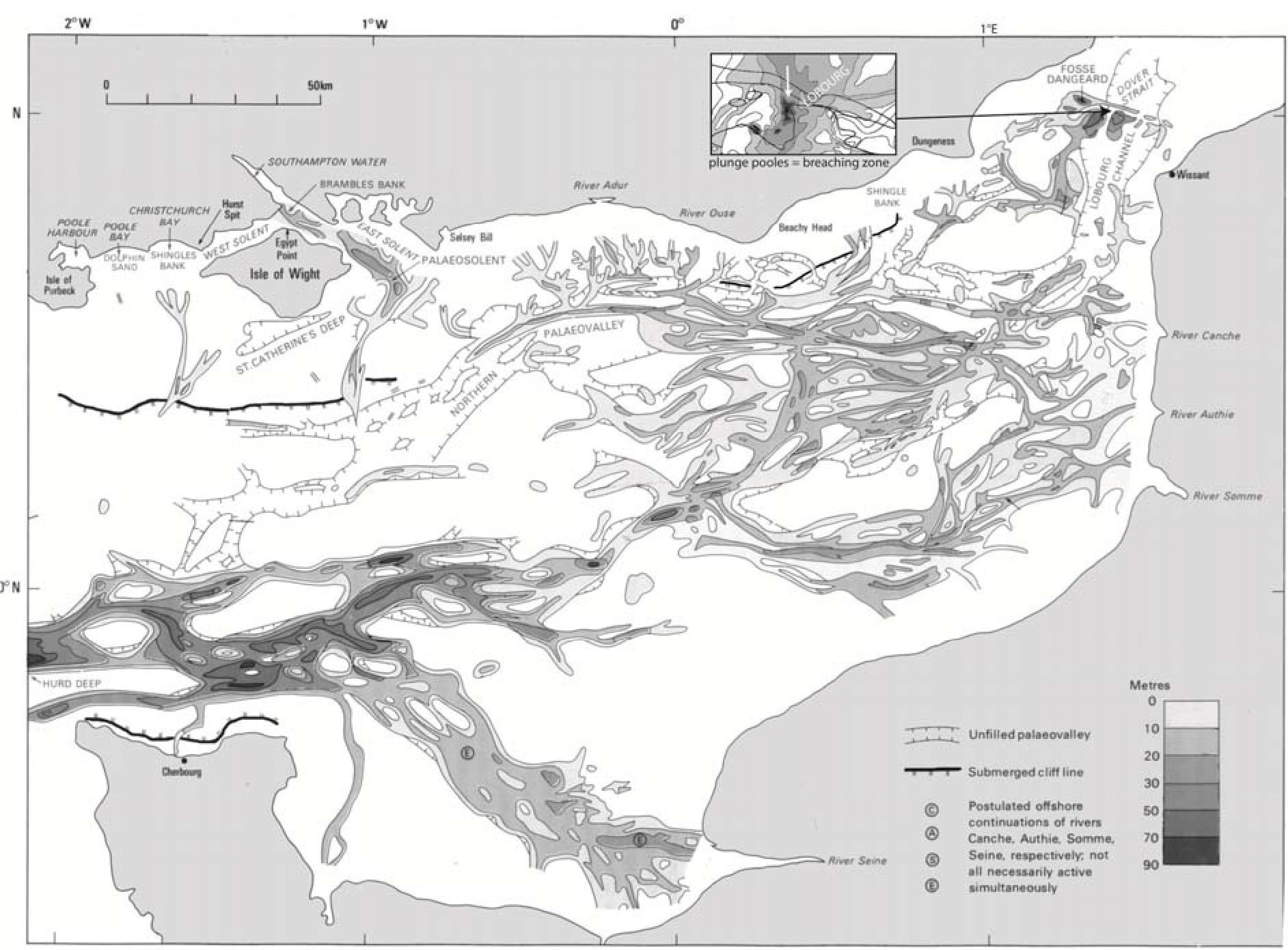
Palaeo-valleys system within the Eastern Channel (from Alduc, 1979, adapted by Hamblin et al., 1992), with the position of the drown paleo-cliffs and the Weichselian Channel. Notice the presence of scouring (plunge pools) in the chalk at the level of the strait (frame) due to breaching of gravel ridges; the Fosses Dangeard limits are marked by a thick line (from the map of Kellaway et al., 1975).
Système des paléovallées de la Manche orientale, avec la position des paléofalaises ennoyées. En encadré, les surcreusements au niveau du détroit (« plunge pools ») liés à la rupture des cordons littoraux anciens.
The Old paleo-valley system of the English Channel
West of the Strait of Dover, the main characteristic of the Eastern Channel, mostly East and south of the Isle of Wight is the system of paleo-valleys which has been originally described (Alduc, 1979; Auffret et al., 1980) as a complex “old” system. A more superficial one exists connected to the Lobourg Channel (fig. 8). Fluvial incision in response to basement uplift is a well-documented phenomenon (eg. Schumm et al., 2000). The Eastern Channel valley morphologies are perfectly controlled by Cadomian tectonic structures parallel with and in the prolongation the Hurd Deep system and the Lizard suture zone in the Western Channel (fig. 3). They are moreover influenced by late Variscan structures, such as flexures inherited fronts like the Variscan oversthrust or Permo-Triasic tension faults, most of them being reactivated during the tectonic inversion phases. The northern edge of the Hamsphire Dieppe basin (HAB) is controlled by the southern flexure of the Boulonnais, guiding the Paleo-Canche River across the channel. Both valley systems have been attributed by Alduc, 1979 and Auffret et al., 1980 to the regressions during Quaternary events.
Figure 9
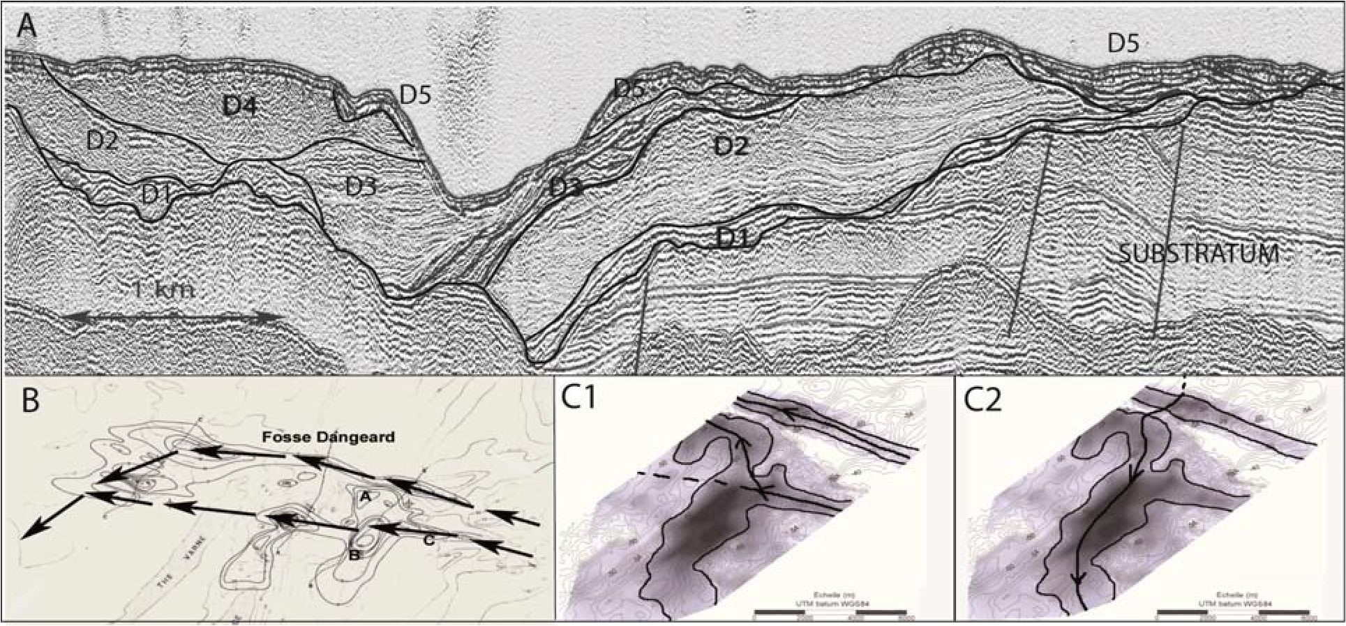
A: Seismic section across the Eastern Dangeard Deep, crossing the Lobourg Channel. Shape (B) and flowing (C) direction of the paleo-valleys (Delestret, 2004). C1 = D2 units.; C2 =D3
A : Profil sismique au niveau des Fosses Dangeard Est. Morphologie (B) et direction d'écoulement (C) au niveau des paléovallées. (Delestret, 2004). Unités. C1 = D2; C2 =D3
To the West, the last major incision has been also dated on land and on the near offshore to the base of the Tortonian by ESR (Electron Spin Resonance ; Laurent et al., 1998; Van Vliet-Lanoë et al., 2002, Van Vliet-Lanoë et al., 2009; Paquet et al., 2010). We had correlated the northern paleo-valley system responsible for the terraces described by Alduc, 1979 and Auffret et al., 1980, with the Late Miocene uplift of the Strait of Dover (Van Vliet-Lanoë et al., 2004) and the renewed opening of the strait during the Pliocene by capture of the Eastern Channel river net by the North Sea (differential subsidence). This reopening of the strait is associated with the splaying of Tortonian gravels on the floor of the eastern ChannelThis paleo-valley system seems correlative of the Mio-Pliocene Cockburn formation in the WA. All theses Mio-Pliocene valley systems, probably retrim olders, as the late Oligocene (Jones, 1990) responsible for the Jones formation but also a Mid Eocene paleo-valley system (Lutetian-Bartonian) feeding the HDB. It seems probable that the Paleo-Seine system (fig. 9) is already Mid Eocene in age, seeing the superimposed character of the meander tracks on land and the abundance of “Ladères” sandstones on the middle terrace. Similarly, the incision at the base of the lower Lutetian in the SNSE (Vandenberghe et al., 1998;- 2004) is controlled by a regression at the end of the Ypresian (Hardenbol et al., 1998) more important following the eustatic curve of Miller et al., (2005; fig. 4). It coincides with the major event of tectonic inversion in Western Europe (Ziegler, 1992).
Three main systems of paleo-valleys are thus evident in the eastern English Channel : 1° an Eocene-Oligocene system characterised by several generation of shallow valleys, often filled with late Eocene sediments, truncated by a main abrasion surface, 2° an Miocene system already well incised, related to the long emersion of the Channel during the Lower and Middle Miocene, and 3° late a Mio-Pleistocene system with two terrace levels already in connexion with the Lobourg channel. The second and third systems correspond to the “Fleuve Manche” (Lericolais et al., 1996; fig. 6). These fit with the D2-D3 and D4 units of the Fosses Dangeard.
4) The young palaeo-valley system: the Plio–Pleistocene emersion and the breaching of the Strait of Dover
The strait is closed from 1,79 Ma. With the accentuation of the sea level drop during glaciations from the Mid Pleistocene Transition (0,9 Ma), the Channel is emerged for long periods (Funnel, 1996). The youngest valley system corresponds to units D5 of the Fosses Dangeard. Concerning the Plio-Pleistocene times, the detailed works of Zagwijn (1989) and Funnel (1996) have brought complementary data. It is especially the case for the position of the successive shorelines in the southern North Sea basin which migrated progressively to the West with the Pliocene flooding, then retracted to the East, during the Pleistocene: this evolution is partly related with long wave length deformations affecting the Anglo-Brabant massif and the Variscan Front (Van Vliet-Lanoë et al., 2002) but also with the mean interglacial sea level drop consecutive to the building of the Antarctic and Greenland ice sheets (Funnel, 1996). Raised shoreline anomalies also result of long wave length deformations in the English Channel and Southern North Sea regions (Van Vliet-Lanoë et al., 2000) attesting of the persistence of pulsed tectonic events during the Quaternary. The empty character of the NW paleo-valley may be partly attributed to erosion with recurrent transgressions.
The most recent valley system shows wide sinuous valley in the eastern Channel, mostly flat bottomed, with a braided system. It is commonly attributed to the Last Glaciation. A deep scouring incises the strait and also the paleo-valley system south of the Isle of Wight, at the emplacement of the Hurd Deep. The only core performed on the Fosses Dangeards cuts a peat interpreted as MIS 5d (Amersfoort), following Morzadec (in Kellaway et al., 1975). In 2002, we succeeded too to produce a core, recording three “interglacial” coarse gravels interbedded with two levels of laminated, mica rich silts, devoid of fauna, which are similar to distal glacio-fluvial deposits with traces of ice segregation. It seems thus that this record which shows some evidences of the outlet of the North Sea paleo-lake probably covers more than a single glacial-lake event.
Smith (1985), Gibbard (1995), Gupta et al. (2007) and Toucanne et al. (2009) among others have suggested that the initial “official” breaching of the Strait occurred during the Anglian (MIS 12 or 0,42 Ma only, in their view), although the “breach” was prepared by a graben during Early Quaternary (Colbeaux et al. 1993). Gupta et al. (2007) argued for the possible breaching of a proglacial lake during MIS 12 and MIS 6 leading to several megafloods rushing through the English Channel. This interpretation is mostly based on the morphology of the paleo-valleys partly copying these of the Scablands in Western USA. In parallel, Toucanne et al. (2009) showed that large inputs of glacial sediments occurred on the bottom of the Biscaye gulf about 150 ka ago, in relation with breaching events related with rapid meltdown of the Scandinavian ice sheet. He suggested too that a similar system during MIS 12. The breaching of a “chalk ridge” stressed by Gupta et al. (2007) seems improbable seeing the strait history and the seismic profiles (fig. 9). The breaching was probably eased by the gravely nature of the raised beach ridges crossing the strait.
The event at 150-160 ka seems valid, as the strait shows a set of 3 scourings (fig. 8; plunge pools) incised in the chalk in its central part (down to -50 m for the main one). This is related to the maximal efficiency of erosion at the outlet of the “breached” reservoir (Rudoy, 2002). It does not correspond to a former sedimentary infilling of the Fosses Dangeard. Also the change in loess mineralogy in the Sangatte Beds (Balescu et al., 1988) seems demonstrative. Other arguments are the major changes in sedimentation along the Picardy coast, an increased erosion rate on the coastal cliffs of the Boulonnais since MIS6 (Gosselin, PhD in preparation) and the preservation on erodible marls of a 9 m terrace covered by beach gravels SE of Watten in the St Omer basin, tracing probably the shore of the paleo-lake. Downstream of the strait, flat bottom braided channels, with some acceleration in narrowing are typical for periglacial or fluvio-glacial discharges in permafrost landscape. As observed at the level of the Hurd Deep or in the Northern paleo-valley (South of Wight Island), the over-deepening may be attributed to tidal scouring in a rather narrow, tectonically controlled valley during the rise by step of the sea level at the end of MIS 2 or earlier.
Concerning the MIS 12 event, it is evident from Toucanne et al., 2009 data, but much less probable at the level of the Strait of Dover due to the temporary tectonic uplift from 600 ka to 280 ka (beginning of the tectonic relaxation) and the malacofaunal observations of Meyer and Preece (1995). It probably issued from another fluvio-glacial source, as eg. the St George Channel, at the southern entrance of the Irish Sea.
5) The phases of inversion and their signatures: could the Strait of Dover be an element of the European rift?
As described higher, the major feature is the inversion of Mesozoic deposits as the Weald-Boulonnais and the Bray structures which initiated in late Cretaceous (Laramian phase). It reached a maximum of activity during the Late Eocene (Ziegler, 1992, Coward, 1994) and Late Oligocene - Early Miocene phases (Badley et al., 1998; Mansy et al., 2002; Hillis et al., 2008). Correlative deposits are first stored in the Hampshire-Dieppe basin, limited to the West by the Cotentin high. After with the main phase of inversion in the Western Approaches, seeing the tectonic orientation in this zone, some blocks are presumed subsiding like the Hurd Deep (Lericolais et al., 1996), with mostly dextral strike-slip deformations. These guided from the shelf edge retrogressive erosion linked to the onset of glaciations. Thanks to this, the English Channel drained to the Atlantic from the Oligocene, the onset of the “Fleuve Manche”.
Western Europe also suffered a global post-Atlantic rift thermal subsidence. The prevailing meridian stress field reflects a combination of forces related to continuing counter clock-wise convergence of Africa–Arabia with Europe and North Atlantic ridge push (Nielsen et al., 2007). In the Viking graben, at the North of the North Sea, the Paleocene phase corresponding to the backlash of the opening of the middle North Atlantic (Greenland-Norway) reactivated the pre-existing rifts (Vialy, 1988). Most of the elements of the European rift began to activate from the Middle Eocene by retrimming of Variscan, Permo–Carboniferous and Mesozoic crustal-scale faults (Ziegler, 1992) also controlling basin inversion in the southern North Sea and Western Shelf areas. The formation of large grabens was active mostly during Late Eocene and the Lower Oligocene, usually reactivating Permo-Triasic structures.
We have seen that rivers already occupied the Strait of Dover probably prior to the Bartonian (Warcove). This means that a pre-existing shallow saddle connected the Eastern Channel and Southern North Sea Basin, driven by W-E extension complementary to the direction of the main meridian stress field build both by the Northern Atlantic widening and the Laramian orogen. Some subsidence probably existed already during the Bartonian as expressed by frequent co-seismic and slump structures in the Lower Slack Beds and in the HDB. A renewed subsidence of the saddle certainly occurred from the Middle Eocene to the Rupelian, before being lifted up and tilted by a renewed inversion due to the main Alpine phase.
In the early Oligocene, 33 Myrs ago in the Northernmost Atlantic, relative plate motion between Greenland and Eurasia changed from right-lateral shear to oblique divergence as marked by the onset of deep-water massive exchange through the Fram Strait; this was probably formed during early Miocene times (20–15 Ma) (Engen et al., 2008). During the Oligocene–Miocene, subduction resistance of the European foreland increased (Dèzes et al., 2004), in relation with Alpine Orogen (formation of the Jura). In combination with the change in the Northern Atlantic, it leaded to a shift from compression to extension from 20 Ma to c.10 Ma ago (N150). Evidence of renewed subsidence exists from the early Pliocene sealed by the Middle Pliocene of the Pointe-Aux-Oies. Inversion continued at lower intensity during the late Neogene and the Quaternary, despite the shift of regional stress field back to N170° (Bergerat 1987; Bergerat & Vandycke, 1994). The subsidence of the strait certainly continued as shown by fault activity recorded at Sangatte around 160 ka (a total vertical offset of 6 m).
Figure 10
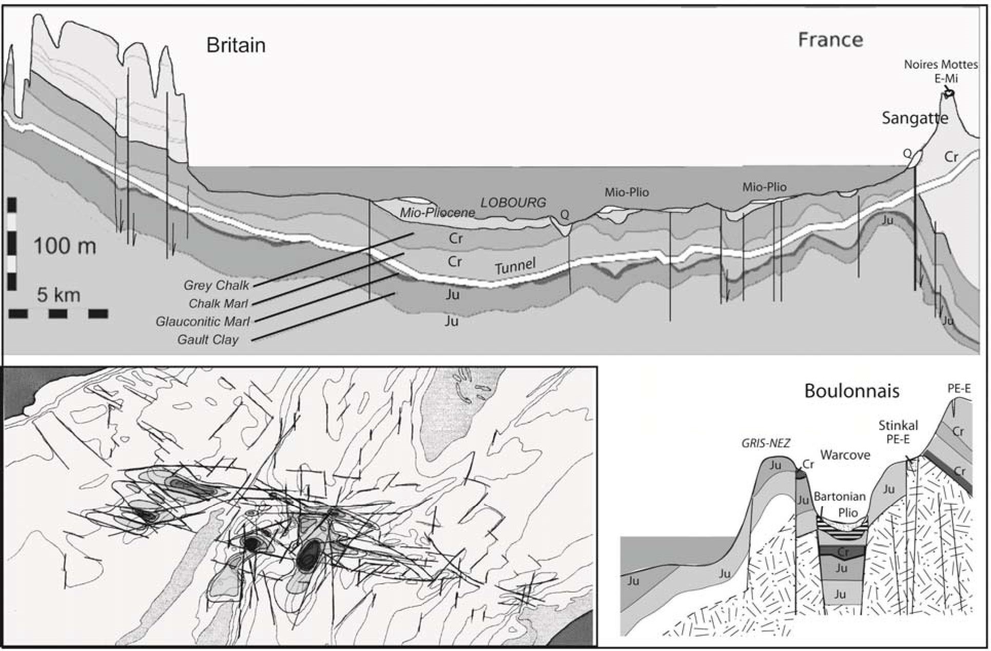
Geological section of the Channel Tunnel (simplified from MTL-BRGM –Mott, Hay and Anderson) compared with a parallel cross section at the level of Cape Gris-Nez (base : geological map of Marquise, Mansy et al., 2002). Detailed lineaments at the level of Fosses Dangeard (map from Kellaway et al., 1985). PAL: Paleozoic substratum, Ju: Jurassic beds, Cr: Cretaceous beds, PE-E: Thanetian + Sparnacian; E-Mi: Eocene + Late Miocene; Plio: Middle Pliocene. Q: Quaternary (on the main section).
Coupe géologique du tunnel sous la Manche comparée à une coupe parallèle au niveau du Cap Gris-Nez (base : carte de Marquise, Mansy et al., 2002). Linéaments au niveau des Fosses Dangeard, extraits de la carte de Kellaway et al., (1995).
The Strait of Dover may be interpreted as a dissymmetric “graben” (fig. 3 and 10), not only restricted in time to the lower Quaternary (Colbeaux et al., 1993), but well located on a mega-structure in inversion since the Late Cretaceous, the Variscan Oversthrust. Other true crossing of the Variscan front by the European Rifts led to an interruption of the graben. It is the case of the Saint Georges Channel, at the entrance of the Irish Sea or the interconnection between the Lower Rhine and Upper Rhine grabens, somewhat perturbed by the Eifel Hotspot. But most of them are located on former Permo-Triasic structures. The Strait of Dover structure develop on a thick, brittle crust, lacking Permo-Triasic (PT) graben structures but with P-T meridian conjugated faults, reactivated in sinistral strike-slip, mostly in a zone of thin Mesozoic cover (thin skin tectonic) by comparison with the whole Weald basin (Mansy et al., 2003). The potential occurrence of a granitic batholith north of the Strait of Dover (Minguely et al., 2005) may also complicate its expression. The difference in structure between the Weald, the Boulonnais and the Artois suggests weaknesses inherited from the Avalonia micro-continent formation (Caledonian orogen).
The strait zone seems thus recording a similar chronology of development as the European Rift. Moreover the N-S lineation's (fig. 3) extracted from the topography shows clearly a cluster of features in the prolongation of the Massif Central-Limagnes graben system. We may thus wonder if this element in the landscape of Western Europe could be considered as extensional structure, on a pre-existing structural weakness, limited in expression due to the discrete uplift and tilting of the Varsican overthrust. The closing of the strait from 1,79 Ma attests of the continuation by steps of the inversion. The Pliocene-Pleistocene accelerated subsidence of the North Sea basin and the contemporaneous tectonic uplift of the Fennoscandia shield reflect deflections of the lithosphere in response to the build-up of the present-day, nearly meridian, compressional stress field in NW Europe (e.g. Van Wees & Cloetingh 1996; Van den Berg, 1996). It favours a renewed subsidence at the level of the strait with a last event during MIS 6.
V. — Conclusion
The Strait of Dover is no more a quaternary anomaly in the geology of Western Europe; it seems to be a very old feature retrimmed several times during the Cenozoic. The main shaping phase of the Boulonnais post-date the Laramian tectonic phase and seems already established after the PETM. The early phase for the shaping of the old paleo-valleys in the eastern Channel is probably late Ypresian, reactivated during the Mid Eocene, during the emersion of the Chattian to the Pliocene in association with main inversion events, ending with the Messinian crisis. The opening of the strait is controlled both by the recurrent Cenozoic uplifts / tilting of the Variscan front due to the combination of the Alpine orogen and the opening of the Northern Atlantic and by the global eustatic control. The strait is also subsiding by steps during the inversion's phases. The Strait of Dover may be considered as an extensional structure, limited in expression due to the crossing of the reactivated Variscan front as it records a similar chronology of development as the European Rift. Its position within the Eastern European Rift is coherent with the development of these of the Massif Central and the Rhine system (fig. 2) (Alpine compression + N.Atlantic opening). The “Fleuve Manche” is also an old feature that developed with the onset of the Neogene.
Acknowledgments. — We greatly thank Noel Vandenberghe and Francis Amédro for their suggestions to improve the stratigraphical content and the clarity of this manuscript.